 The lobby of the Treworgy Planetarium holds a permanent exhibit on 19th-century navigation that is divided into six stages. By going through the exhibit you can learn how sailors found their destinations in the years before GPS.
Round Earth to Flat Map
This section of the exhibit details the process of making a flat chart from the world which is round. It includes a discussion of different types of maps and points out some of the advantages and disadvantages of each type.
Direction and Speed: Dead Reckoning Taffrail log, Accession Number: 1934.9 In order to know where your ship is located, you must know the direction you are traveling and the distance you have moved. Finding the direction was easy with the use of a compass, but finding speed, or distance covered, was more difficult. Sailors would let out a log on a rope and measure how much of the rope had been pulled off the ship in 14 seconds. Then, they could compute how fast they were traveling and the distance that they had traveled. This reckoning was subject to error from currents and wind.
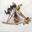
Measuring an Angle SextantThe primary tool in celestial navigation is a sextant. This is a protractor which measures the angle from the horizon to a celestial object. If sailors knew the angle their ship was from a few specific stars, and knew where the stars were located, they could pinpoint their position in a vast ocean.
Finding the Latitude
This part of the exhibit contains information about GPS satellites, a plastic diorama depicting how one finds latitude, and a copy of the Winslow Homer painting Eight Bells.
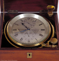
Finding the Longitude ChronometerThis section of the exhibit shows the importance of accurate timekeeping in finding longitude. If sailors had accurate chronometers they could keep Greenwich Mean Time. Then, using a sextant to measure the angle of the sun, they could, with numbers from the nautical almanac, determine where their ship was.
You be the Navigator
In this final section of the exhibit, a sextant is set up against a wall with the sun and horizon painted on it. You can use the sextant to find the angle from the sun to the horizon.
The Orrery
On the ceiling of the Planetarium is an orrery–a mechanical scale model of the solar system. Mercury, Venus, Earth, Mars, Jupiter, Saturn, Uranus, and Neptune are shown.
The sun should be at the center, but cannot be shown because of the compressed distance scale used in the orrery. Made to the same scale as the planets, the sun would be over seven feet in diameter! Pluto is too far from the sun, on this scale, to be included.
Orrery Scales
-Diameters of the Planets: 1 inch = ten thousand miles
-Distances of the Planets: 1 inch = fourteen million miles
-Time Scale:1 minute = eighty-eight day-


